

AI Georeferencer for Aerial Imagery
The AI Georeferencer in Mundi takes any PNG, JPEG, WEBP, PDF or TIFF, and turns it into a GeoTIFF automatically. It works by comparing your image directly to local reference imagery to detect ground control points, just as you would if you were manually georectifying it in ArcGIS or QGIS. Our AI takes 10 seconds per image, on average, and gives you the ground control points (GCPs) so you can manually adjust after.
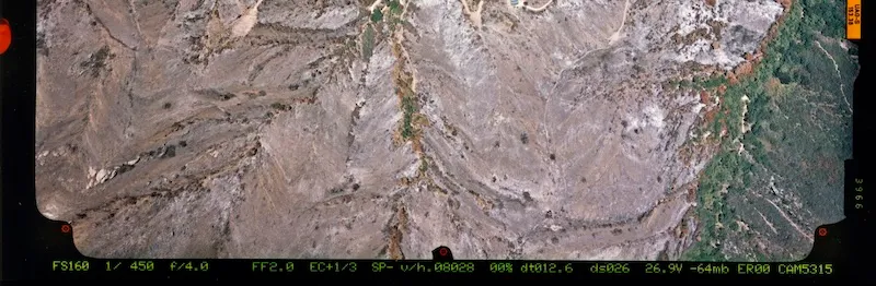
Because our AI is robust, it works on satellite and aerial imagery, both historical and modern drone photography, and scanned maps with annotations or legends. The most common use case is bulk georectifying of scanned analog aerial photographs like this one:
How to use the AI Georeferencer
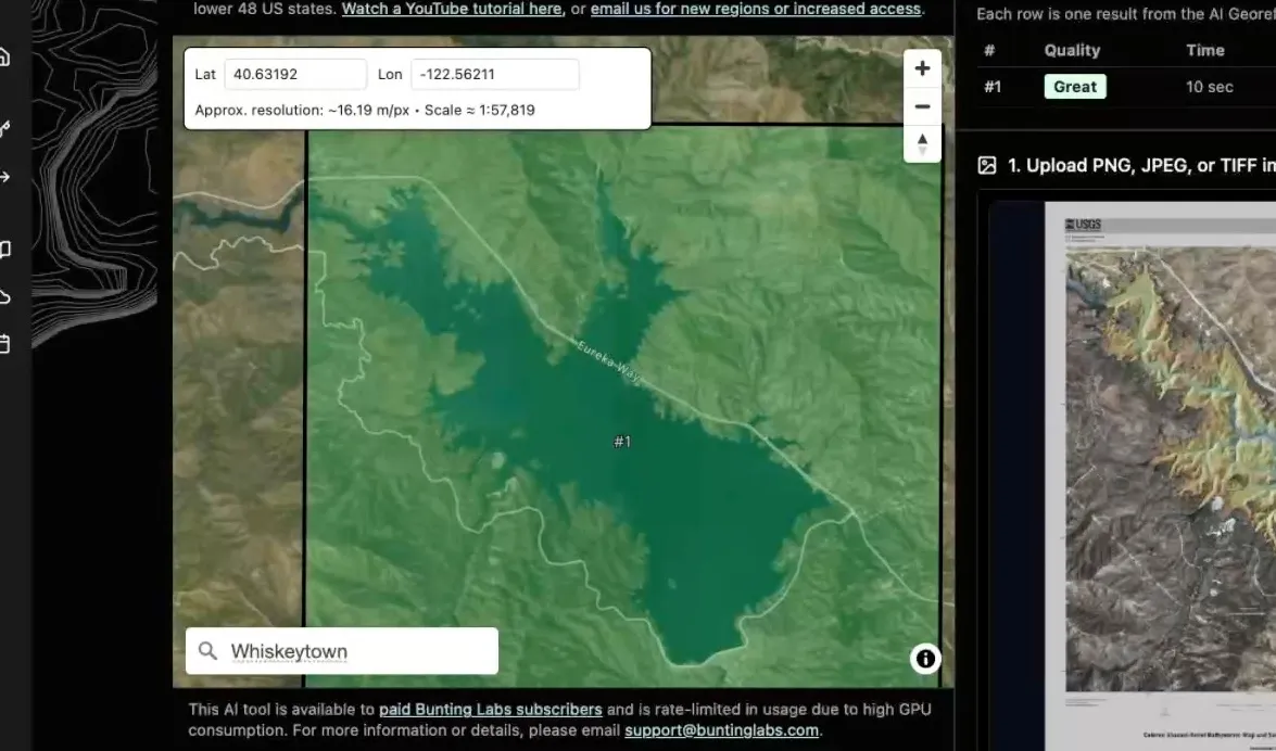
Section titled “How to use the AI Georeferencer”In this guide, we will walk through georeferencing a USGS bathymetric map of Whiskeytown Lake, California. Despite its thick white border, legend, and overlaid bathymetric symbology, the georeferencer achieves 2-3 meter accuracy on its first try.
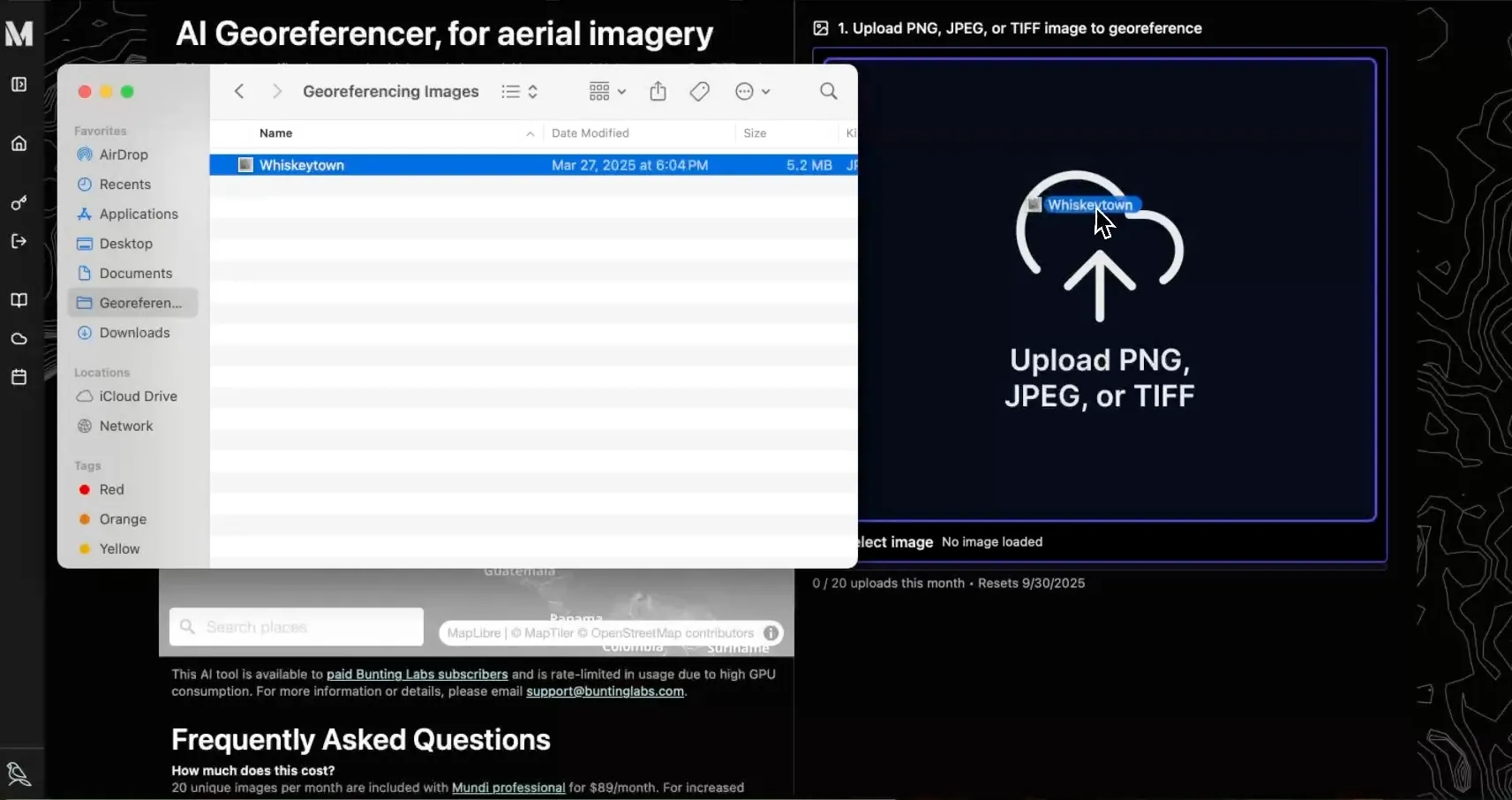
Upload the target image
Section titled “Upload the target image”The first step is to upload the image you want to georeference. The tool accepts PNG, JPEG, or TIFF formats.
You can either drag and drop your file into the upload area on the right side of the screen or click the area to open a file selector.
Zoom to the approximate location
Section titled “Zoom to the approximate location”Once your image is loaded, you need to provide the AI with a general area to search for matches. On the left-hand map panel, navigate to the approximate location of your image. The AI can see the bounding box of your map and your zoom level.
You can do this in two ways:
- Search: Use the “Search places” bar to find a known location by name, like a city or landmark.
- Coordinates: If you know the approximate latitude and longitude, you can enter them in the boxes at the top of the map panel.
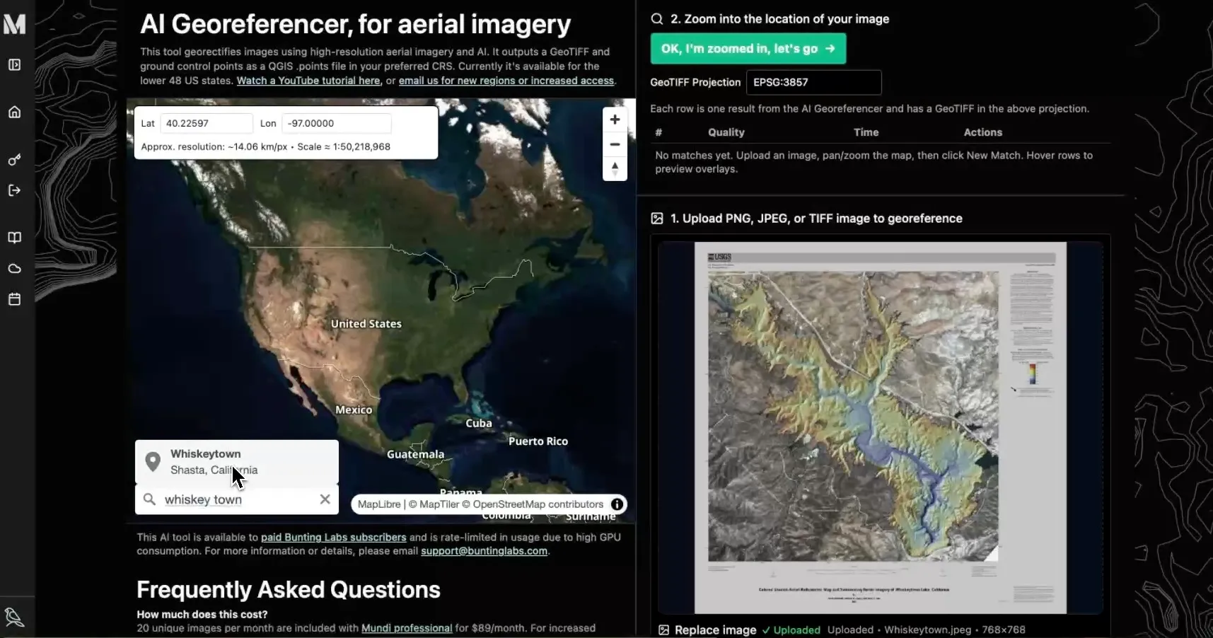
For this example, we’ll search for “Whiskeytown”. The map will automatically pan and zoom to the correct location in California. The zoom level does not need to be exact, but the map view should contain the full extent of your uploaded image.
Run the AI Georeferencer
Section titled “Run the AI Georeferencer”With the map correctly positioned, click the green OK, I’m zoomed in, let’s go → button. The AI will immediately begin processing.
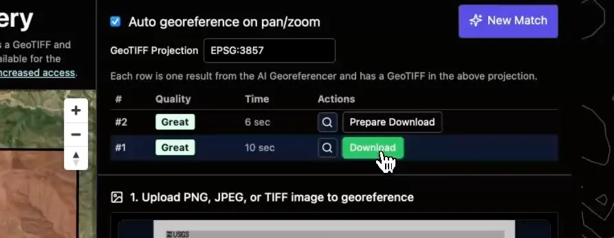
The tool automatically detects changes in the map view. If the initial result isn’t accurate, you can simply pan or zoom the map slightly, and the AI will automatically run again to find a better match. To maintain manual control, disable “Auto georeference on pan/zoom” and hit New Match each time.
Within about 10 seconds, one or more potential matches will appear in a table above the image upload area. Each match is given a quality rating, such as “Great,” “OK,” or “Poor.”
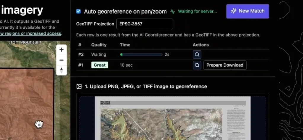
Preview the geotransform bounds
Section titled “Preview the geotransform bounds”Before downloading, you can verify the accuracy of the match. Hover your mouse over a result row in the table. A preview of your georeferenced image will be overlaid on the map panel with partial transparency, allowing you to see how well it aligns with the underlying base map.
Downloading as a GeoTIFF
Section titled “Downloading as a GeoTIFF”Once you are satisfied with a match, you can download the georeferenced output. Because the AI Georeferencer is a GPU-intensive process, downloading the final results requires a Mundi Professional subscription.
- Click the Prepare Download button on the row for your chosen match.
- The system will generate a ZIP archive containing the GeoTIFF and a GCP file. Once ready, the button will change to Download.
- Click Download to save the archive to your computer.
The ZIP file contains:
- A GeoTIFF (
georeferenced.tif) warped using the best GCPs. - A GCP file (
.points) that can be loaded into QGIS for manual warping or inspection.
The GeoTIFF will be in the projection you requested, which defaults to EPSG:3857.
Here is the scanned analog aerial photograph that we mentioned earlier, after using the AI Georeferencer on it while zoomed into Santa Barbara, CA. Note that it’s been rotated nearly 180° automatically by the AI.
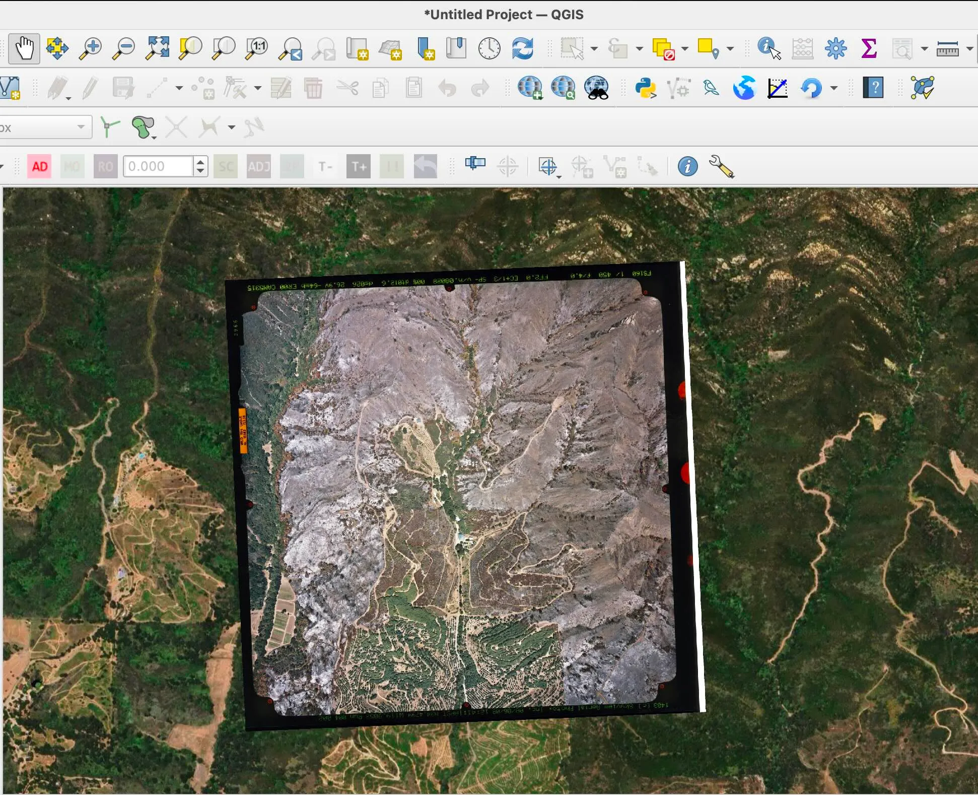
You can drag the resulting GeoTIFF into most GIS software, like QGIS or Mundi.
Accuracy and troubleshooting
Section titled “Accuracy and troubleshooting”Once the AI successfully locates your image, you should expect 1-3 meter accuracy, depending on your zoom level. Individual ground control points may have higher error, but the overall warp is generally very precise.
- Low-Resolution Imagery: If your input image has a resolution lower than 1 meter per pixel, the final accuracy will be limited by your source data. Expect an error higher than one pixel’s equivalent ground distance.
- Poor Initial Match: If the result’s bounding box is dramatically off, the AI may need a better hint. Adjust the pan and zoom of the map on the left and the tool will automatically rerun. Zooming in closer to the target area often helps.
Technical details
Section titled “Technical details”Input image requirements
Section titled “Input image requirements”For the best results and performance, please adhere to the following guidelines for your input image:
- File Size: We recommend keeping uploaded input images under 25 MiB.
- Dimensions: It is not advantageous to
provide an image with its longest edge greater than 2,000 pixels. For very
large images (over 10,000px on one side), the tool will downscale the output.
To georeference very large images, it is better to pass a downsampled version
to the tool and then use the resulting GCP
.pointsfile to warp your original high-resolution image in a desktop GIS. - Resolution: We recommend an input image resolution no higher than 0.25 meters per pixel. For aerial or drone imagery with higher resolution, you will get better performance by downsampling it beforehand.
Warping algorithm
Section titled “Warping algorithm”We generally warp using a third order polynomial and cubic resampling.
Projections
Section titled “Projections”You can request any output projection for your GeoTIFF, but ground control points are detected and matched in Web Mercator (EPSG:3857).
Orthorectification
Section titled “Orthorectification”The tool does not directly incorporate a Digital Elevation Model (DEM) in its calculations. This may result in mountain ranges not being uniformly and correctly located. However, our reference aerial imagery is orthographic.
Region support
Section titled “Region support”The AI georeferencer has global support for up to 10 meter resolution with Sentinel-2. In specific regions, we have high resolution reference aerial imagery. We automatically route reference imagery from the highest resolution reference imagery we are licensed to use.
High resolution regions
Section titled “High resolution regions”- Continental United States (lower 48 states)
- Netherlands
- Poland
- Spain
- France
- Switzerland
- Taiwan
- Japan
All regions except CONUS have 30cm resolution. CONUS is at 1m resolution.
We are adding new regions one by one to ensure our reference aerial imagery is high-resolution and accurately georectified. If you would like to request support for a new region, please email us at support@buntinglabs.com.
Attribution
Section titled “Attribution”Sentinel-2 cloudless - https://s2maps.eu by EOX IT Services GmbH (Contains modified Copernicus Sentinel data 2016 & 2017)